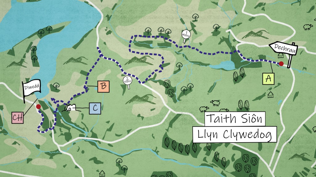
Duration: 2 hours and a half
Distance: 4.5 miles
Start: SN 949 874
End: SN 911 869
Parking: You can either park at the start of the walk: Van Terrace, Van, Llanidloes, Powys SY18 6NW, or at the end of the walk: Llyn Clywedog, Llanidloes, Powys, SY18 6NZ
The walk starts on Van terrace (A). Walk along the terrace towards the West, and after 700 metres turn left to walk down the lane towards Manledd Uchaf Farm. Follow the public footpath through the farm, and after half a mile, take a sharp left to walk on a different footpath towards the southwest. Continue on the path, through Penlcun Farm, and you'll come out on the road.
Cross the road and join Glyndŵr's Way (B) towards the West. Follow Glyndŵr's Way for a little over 1 kilometre. You'll reach the ruing of Bryntail (C). After visiting the old lead mine, continue to walk on the path across the river, and follow the road to reach the top of the dam on Llyn Clywedog (Ch), where the journey ends.
A) Van Terrace
Grid Reference: SN 949 874
These terraced cottages were purpose built for the nearby Lead factory workers, which was the largest in the world at the end of the 19th century.
B) Glyndŵrs Way
Grid Reference: SN 920 872
Glyndŵrs Way stretches across 135 miles, starting in Knighton and ending in Welshpool.
C) Bryntail Lead Mine
Grid Reference: SN 915 869
Bryntail closed in 1884 as the local mining boom came to an end. The remains that still stand include crushing houses, ore bins, roasting ovens, smithy and the mine manager's office.
Ch) Llyn Clywedog
Grid Reference: SN 91209 87008
The Llyn Clywedog is a man-made reservoir formed by the construction of the Clywedog Dam. The lake has a surface area of 615 acres, is 216 ft deep at its maximum depth and stretches in all a distance of six miles.