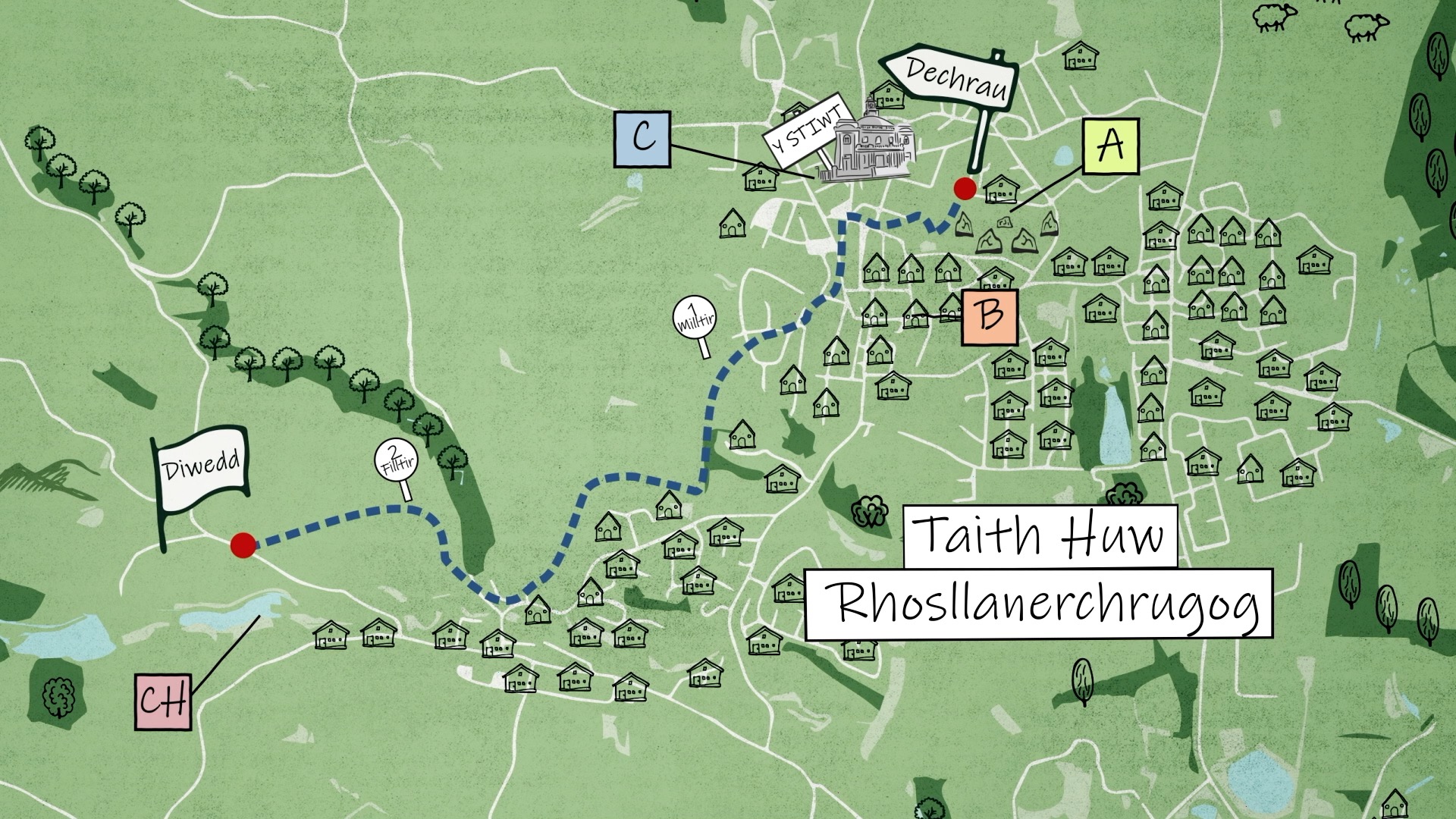
Duration: 1 hour 15 minutes
Distance: 3 miles / 5 kn
Start: SJ 295 466
End: SJ 265 452
Parking: There's a car park at the start of the walk at the bottom of School Lane, Ponciau, LL14 1RP. There isn't an official car park near the end of the walk, but plenty of on street parking at Chapel Street, Penycae, LL14 2RF.
This is a straight walk. There's a place to park at the start of the walk, and near enough to the end of the walk.
The walk starts by the northern entrance to Ponciau Bank Park (A). Walk directly through the park toards the south, and after around 200 meters, turn right and walk through the Gorsedd Stones (B). Continue to walk towards the west, and come out of the park on Broad Street. Continue to walk in the same direction and you'll see The Stiwt (C) on your right.
After visiting The Stiwt, keep walking and when you reach a mini roundabout, turn left, and walk for 250 meters. You'll see a sharp right turn, turn here and follow Brook Street, passing the chapel, following the road round to the left, then right onto Heol Caradoc.
Walk to the bottom of Heol Caradoc and before reaching the I D Hooson school gates, join the footpath on the right. Once you've joined the path, turn left and walk for 100 meters. Then, turn left to join a different footpath towards the South. Continue to walk straight on this path, and you'll come out on Stryt-Issa. Turn right, passing the entrance to the rugby club, and take the next right to join the footpath.
Follow this footpath behind the houses, keeping left when the path slits to two. You'll come out on Poplar Road in Pen-y-cae. Turn right, and follow the road around for a bit, then turn right to walk up Lambpit Street. As you pass Pentre Farm on your left, go straight onto the field, following the public footpath signs, instead of following the road around to the right. Follow the footpath across the fields, carefully, closing any gates behind you. You'll come out on Bridge Street. Turn right on the road and take the first left. Walk on the lane passing Drefechan farm, and follow this lane as far as you can without going too close to the reservoir as there's no public access here. This is where the walk ends, overlooking Pen-y-Cae Reservoir (Ch) from a safe distance.
To reach the parking place by the end of the walk, pass Trefechan Farm, turn right on Bridge Street and walk all the way down to Chapel Street, Penycae.
A) Ponciau Bank Park
Grid Reference: SJ 295 466
This site stands on old coal mine. It was renovated by a group of volunteers, Friends of Ponciau Banks. Following a successful bid to the Heritage Lottery Fund, Ponciau Banks Park was officially reopened following extensive refurbishment in June 2009.
B) Gorsedd Stones
Grid Reference: SJ 293 464
The National Eisteddfod was in Rhosllannerchrugog in 1945. The Eisteddfod continued every year during the second word war. There's a story that people from the community were stood around these Gorsedd stones when it was announced the war had ended.
C) The Stiwt
Grid Reference: SJ 292 465
Another name for The Stiwt is the Miners' Institute. It opened in 1926, the same year as the general strike, and the Miners' Welfare
Association funded £20,000 towards the build. The miners also donated 20p from their weekly wages to maintain the day to day running of The Stiwt.
Ch) Pen-y-Cae Reservoirs
Grid Reference: SJ 269 455
There are two reservoirs here, Pen-y-Cae Upper that's 7 acres, and Pen-y-Cae Lower that's 5 acres. These reservoirs supply water to Pen-y-Cae and Rhosllannerchrugog.